Saturday, September 4, 2010

More Photo's

Indian Creek

Finger Locks... Purple Camalot's

Conductor Crack 5.10d

Me cleaning, somewhere near the pancake flake pitch.
El Cap
Whats a portaledge... Aren't those things expensive.

5am under the great roof

Tuesday, August 31, 2010

Downhill

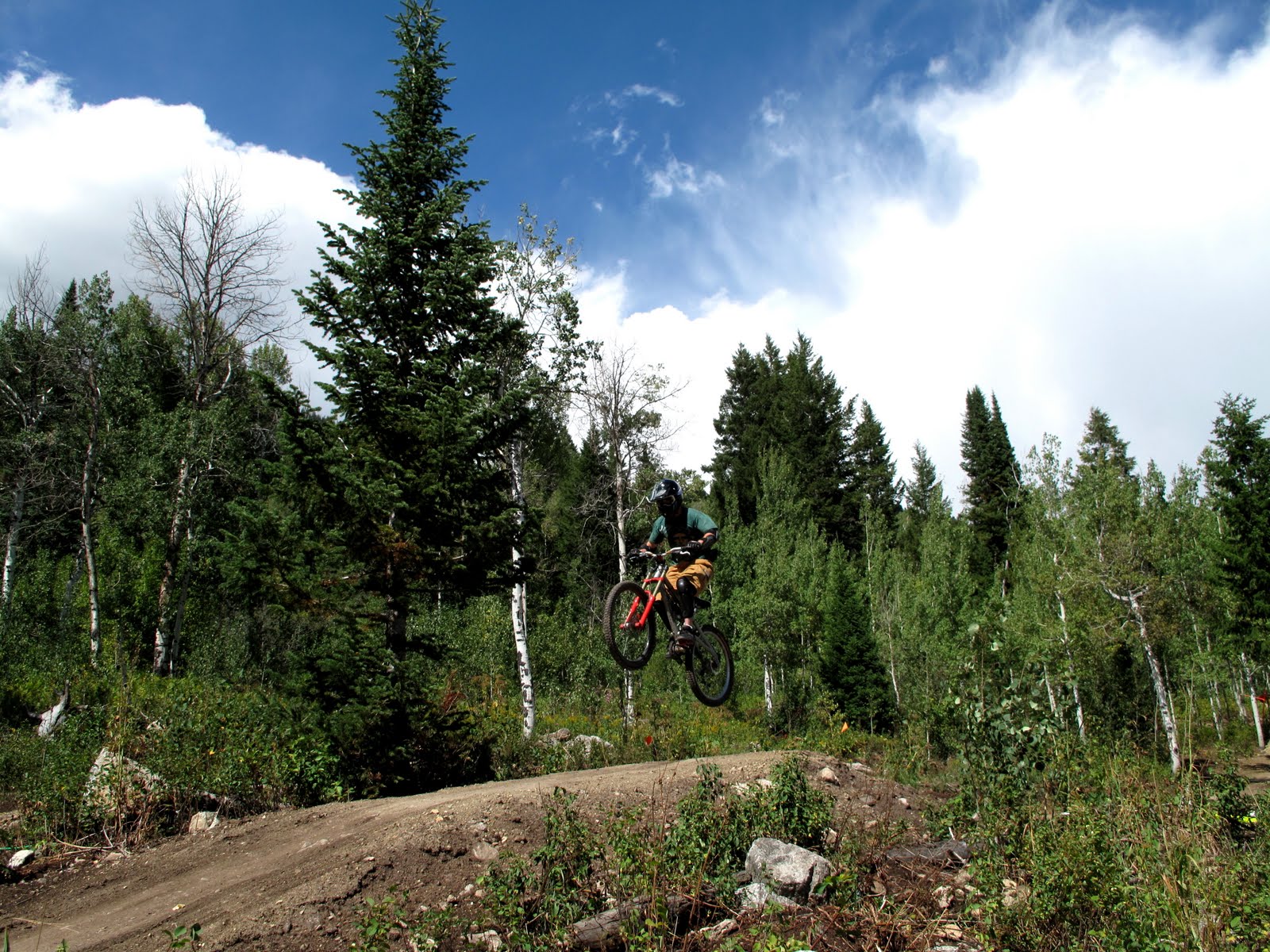
Alright time to switch it up a little bit. The other day me and a few buddies decided to ride the lifts at the resort and rip some of the downhill. Here is a few shots I grabbed. Riders: Mike Zimmer, Jake Stinson, and Randall Townsend

The Grand Teton (13,770 feet)

A summit photo taken with my ancient cellphone.
Grand Teton from the west
               The Rocky Mountains run through the western half of Wyoming and form The Teton range. They rise out of the landscape abruptly and are home to year round snow fields, glaciers and unpredictable rock. The peaks are craggy and rugged and have substantial vertical relief. These characteristics are what give nearby Jackson Hole ski resort some of the best lift access ski terrain in the country. I spent last winter here in Jackson and there wasn't a single day that passed where I didn't look at The Grand and think about standing on top. The first ascent history is vague in that no one is quite certain who climbed the peak first. Most people will recognize William O. Owen along with Franklin Spalding, Frank Peterson, and John Shive as making the first ascent in 1898, however the peak saw earlier attempts. Note (although Owen gets credit, Spalding was the rope gun for this party). In 1872  James Stevenson and Nathaniel Longford claimed to have climbed The Grand, yet by their description and sketches, they most likely climbed the nearby Enclosure peak. It is often said that The Grand Teton strongly resembles Europe's Matterhorn. I had a weather window in the thunder storms that often plague the Tetons and decided to make an attempt. Good thing because it's now snowing above 9,000ft. I planned to solo climb via the Owen-Spalding route. The route traverses north around the west face and then goes up to the summit block. It is described as being exposed in places and gets the rating of 5.4. The guidebook however, lists a few pitches as being 5.5. It is not uncommon to find ice on the route in august.  I got up at 3:30am and put in my Ipod. I spent the morning hours with my thoughts considering my solo and working myself into a state of focus. When I reached the base of the route I took time out to read the topo. There were two guys roping up that eyed me cautiously, and asked me if I wanted to pass and if I was alone. I told them yes and thanked them while moving out onto the west face. The first section was spectacular, as the whole mountain dropped out below me. Moving smoothly across these exposed traversing sections, I reveled in the freedom and commitment of being ropeless. I soon found myself at the base of the Owen chimney. As I started up, I found that a lot of the rock was choked with ice. This made my situation even more delicate. A slip here would have extreme consequences. I moved surgically, checking twice that every hand and foot hold was secure and ice free. As I moved upward passing old petons and layers of ice I felt energized with the thought of standing on top. Easy sections of 3rd and 4th class rock brought me to the summit blocks, and before I knew it I was standing on top. I sat on top for a while and let my mind go blank as I looked out over the Tetons. I uncoiled the rope I had been carrying on my back and began the rappels down. This had indeed been one of the most magical summits of my summer and being alone allowed me to fully appreciate my place in the mountains. 
Sunset behind the Tetons

Tuesday, August 17, 2010

Mt. Whitney (14,496) 8/16/2010

 From left to right; Day Needle, Keeler Needle and Mt Whitney's east face.

          Mt. Whitney is the tallest peak in the lower 48 states. It has two prominent sides that are climbed. There is the surprisingly moderate west side, which offers a long, 22 mile round trip, hiking trail to the top. Then there is the dramatic east side, which is home to more technical climbing. The permit system for hiking or climbing this impressive peak is extremely restrictive, so I was really lucky to obtain a permit the day before I planned on climbing.  My plan was to climb from the east side of the mountain, solo, car to car, in a day. Via the mountaineers route. Admittedly, the route I was planning is the easiest technically on the east side (a scramble), but it would be my first time on the route, I would be alone and I would be going for speed, meaning no extra gear. (yes mom I brought my helmet ;) East side routes are most often climbed in two days. One for the approach into the back country/acclimatization, and one for the climb and decent. I needed to moved fast and take care when climbing and route finding. An alpine start was mandatory, so I crawled into my bag with the alarm set for 4:00 am. I had packed my bag the day before so I could throw it on and start moving immediately. When I woke and went down to the "bear box", I found that someone had left the latch open and a bear had ravaged my gear! I repaired my bag with gorilla tape (really quality duck tape) and started to clean up the garbage. As for my food, Yogi ate my breakfast and my lunch. I had a really nice nectarine, so I don't really blame him. Luckily he left me 5 granola bars scattered in the parking lot. I'm not opposed to sharing but come on!! Ok, four liters of water, 5 granola bars, helmet, rainshell, down jacket, ipod, 14,496 feet. Check.
The scene at 4am. My pack is just out of view with the top torn off...

        After overcoming this little speed bump half asleep, I set out on the trail at exactly 5am. A little late for my liking, but still on track. The route starts on the hikers trail (8,360 ft) and quickly branches off to steeper and more technical terrain. I had spent last week at sea level, so this was going to hurt. Reaching the summit would mean an elevation gain of about 6,136 ft over rough and convoluted terrain. I had set my turn around time for 1:30pm meaning if I wasn't on top by then, I would give up and turn around. It's important to set concrete limits for yourself before setting out into the mountains, and abide by them. This prevents "summit fever" which has been the source of an untimely demise for many climbers. Also, afternoon storms move in quick and without warning.


Sunrise in the Sierras and a long way to go...
 Always reserve time for a quick thank you...


           My headlamp guided me through the early sections of the route and as the sun started to rise I became energized by the setting I suddenly found myself in. The interior of the Sierra mountains is spectacular. It is a seemingly endless kingdom of granite spires and rugged beauty, a place I will be sure to return to with a climbing partner for some of the more technical and challenging peaks. Inspired by location, (and the divided sky jam pumping through my headphones) I kicked it into high gear and started to feel the altitude burn my lungs. Much of the difficulty of this route was maintaining motivation, and route finding. However the last few thousand feet were semi technical loose climbing that demanded my complete focus. I stood on the summit at around 10:45 and descended via the same route. I was able to "scree ski" a thousand foot gully which saved me a lot of time, and had me day dreaming about winter. I was back at my truck at around 2:45pm with a headache from a quick decent and dehydration. All said and done the route took about 9hours and 45min. With about 45 of them sitting on top. Although you always feel you could have done something harder, higher, or faster. It is certainly great training for more difficult and remote alpine peaks and is a step in the right direction!  


Saturday, August 14, 2010

Less Words, More Pictures

Corey Nauman working on his space walk. Muir Wall (El Cap)
        I figure that most people just like to see photography anyway, so I decided to make a post of all pictures. Obtaining quality climbing photos is hard work, as the best ones are usually shot from the top down. Logistically this proves difficult. Usually your proudest or most significant climbing moments are left to memories. Your glory is honest, shared with few people.. When moving fast and light, like on our one day ascent of halfdome, there is rarely room or time for personal photography. Here are a few that we  have managed to collect this summer. Thanks to Shane, Corey, Jerome, Alfredo and anyone else who held the camera.  (Please click each one for a full size image)
Unknown climber in space on the Shield (El Cap)
Me on the final pitch of Lightning Bolt Cracks. (North Six Shooter, Canyonlands, Utah)

Master Cam

Shane Houbart and Corey on the incredibly exposed Lost Arrow tyrolean traverse. 


Amit takes flight on Horseshoes and Hand Grenades. (Tuolumne Medows, CA)
Amit firing the crux and getting the redpoint of Horseshoes and Hand Grenades (12a)


Tighty whities are still hip in Venezuela. (Fredo and Shane, El Cap)

Alfredo Zubillaga on Lost Arrow Spire (w/ Yosemite Falls)
Ok, open the Supertopo big walls book and look at that picture of Tom Frost on the FA of Salathe. Amit Tawfik on Salathe (El Cap, Yosemite CA) 


Thursday, August 12, 2010

Eastern Sierras

The all quartz corridor leading to the summit
              After spending so much time in Yosemite valley, it is a refreshing change to come over to the nearby Sierras. Much higher in elevation, the sierras are home to spectacular alpine climbing in cool temperatures. You won't find crowds over here as the approaches to the classics can take multiple hours. Basing myself from the small ski town of Mammoth provides great access to much of the regions climbing. Yesterday we got acquainted with the area by climbing crystal crag. The route was easy and wandery with a lot of loose rock, but the views were amazing and its a nice way to get yourself back into this particular style of climbing. This route gets it's name from the unbelievable amount of pure white quartz that makes up the summit. Its really strange to climb pure quartz like this as I have never experienced it any where else. Therefore I didn't really know its friction properties. It didn't much matter though because the climbing was extremely moderate. All along the route and at the base you find hand to boulder size chunks of quartz that look like snow; its really cool. 
Colleen with Mammoth lakes down below

Tuesday, August 3, 2010

Jerome and Bertha Climb Leaning Tower In a Heat Wave

Leaning Tower's dramatically steep face
        The morning of of July 16 found Yosemite Valley in the high 90's. Although most climbers had fled the valley for cooler temps, it did not detour the unlikely team of Jerome Smart and Big Bertha. In the early hours of the morning the audacious pair found themselves racking up at the base of the West Face of Leaning Tower (America's steepest wall). Jerome won the rock paper scissors and quickly took the lead. After 400 hundred feet of climbing the two arrived at the bivy ledge and struck camp. Bertha had committed to fixing the next two pitches that evening, but had a panic attack due to the steep and scary terrain above. Jerome, faced with the option of retreat or climb on..., chose to send. The next morning the team awoke to another day of hot temps and Jerome proceeded to take a twenty foot fall on the seventh pitch when the cam he was standing on blew out. Luckily, Bertha is a highly skilled belayer and arrested his fall without incident. Jerome took them to the top of the wall since Bertha was still timid to lead and a bit shaken up after Jerome's fall. When asked how Jerome felt about Bertha not pulling her share of the work all he could say is, "Well, I can't really be too upset with her, she doesn't have any arms or legs."
Bertha out in space engaging in her typical behavior of complete uselessness